
Mount Kinabalu is not as easy as i thought and with the last minute training.I struggle during the climb due to lack of training which usually require at least a month but i only started training 1 week plus before the climb.
The expedition are 3 days on top of the mountain and the trail is as follow according to the map below by Amazing Borneo Tours.
 There're 2 routes that head up to the peak which are via Mersilau and Timpohan Gate.Both of this route still end up at the intersection at Layang-Layang Hut.The difference between this 2 trail is that the Mersilau way is an additional 2km which make up to 6km of the total while the Timpohan way only 4km but with most of trail make up of steep stairs.
We took the Mersilau route up and Timpohan Gate for the descend.
So the ascent from Mersilau to Layang-Layang Hut was still manageable with the uphill and downhill.


One of the many hut scatter throughout the route which provide climber drinking water, toilet and shelter.
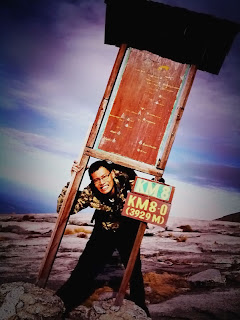
Most of the time our aim is to reach to this signboard which is place at every 0.5km but getting to this sign is so difficult even its just 0.5km apart!

The joyful sign
From the Layang-Layang Hut onward things get a little hard.It rains when i reached there furthermore the path was steep and rocky all the way to Laban Rata Resthouse.The journey from Mersilau to Laban Rata took...

Yes 7hrs 48m
After 7hrs of hike i want my food and rest badly!

Laban Rata Resthouse and the background was the challenge,the Peak(it looks so scary).
Lodge at Laban Rata for dinner and break then only to know that this was not the resthouse that we will be staying.Its actually Gunting Lagadan(no photo) which is another 150m hike...

Breathtaking view

and again..
The part that everyone has been prepared for, final hike to the summit.Went to bed earlier and the hike starts at 2am.The distance from Laban Rata to the summit is 2.7km which seems to be near but it took me 5-6hrs to reach the summit my bad for ignoring the training.
I didn't have any photo taken during the ascent to the summit because it was pitch dark.From 6.0km to 6.5km was still manageable but starting from 6.5km onwards it gets tougher.With the high altitude, air are so thin that i need to stop every 10 steps.At 7.5km untill the summit the gradient of the climb is around 50-60 degree and believe me 200m feels forever.

First light and im way off schedule.

Another 200m more to go but im like stuck on a treadmill!

Priceless experience
The summit was small thou which only fit 4-5 people at a time so everyone took their turns taking picture with 2 aluminum signboard

The rm1 peak
Now the descent,remember the 50-60 degree gradient which is scary when you can see the other way.Look at the signboard below.

There's nothing wrong with the board just that you need to tilt your monitor.

A big fat white rope that guide you up and down

This was like vertical limit.(the man in red was our guide Ah Tung,he runs up and down like spiderman and as fast as superman)

i'am impressed with those porter because they carry 40-50kg at least up the hill like as if it was a handbag and they climb faster than us only with our 2-3kg loads.

Mius Balinting is one of the many porter that provide their super strength service to the mountain.This fella runs 12km from his house to purchase a packet of salt for his wife and runs 12km back.The climbathon is 21km run up and down not 1 way.We took a total of 18hours to reach the top and down,these guys took 2hrs 40m!

Going for round 2?how about i wait you guys at the beach?
